TM 1-1510-225-10
3A-61
transmitters. MAN indicates that fuel flow data has
been manually entered by the pilot and that the entry
must be manually verified and periodically updated.
(e) LAST INPUT. This display shows
the time in hours and minutes since the above three
quantities were verified. This field appears if fuel flow
is input manually.
NOTE
This field displays VERIFY INPUTS at
system turn-on since REMAINING and
RESERVE
are
stored
in
nonvolatile
memory during system shutdown.
(f) HOURS. This field displays the
hours and minutes of fuel remaining until the reserve
fuel quantity is reached.
(g) RANGE. This field displays the
nautical mile range available until the reserve fuel
quantity is reached.
(h) NM/LB. This field displays the
number of nautical miles flown for each pound or
kilogram of fuel consumed.
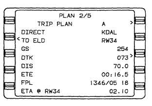
(2) Plan 2/5 Page, Trip Plan. Refer to Figure
3A-39.
(a) TRIP PLAN. This field displays the
selected flight plan by an A for active flight plan or a
number (1 to 56) for a stored flight plan.
(b) FR.
The
from
(FR)
waypoint
identifier is followed on the same line by the first
waypoint (origin) on the selected flight plan. The FR
waypoint may be replaced by DIRECT.
Figure 3A-39. Plan 2/5 Page, Trip Plan
(c) TO. The TO waypoint identifier is
followed on the same line by the last waypoint
(destination) on the selected flight plan.
(d) GS. Groundspeed (GS) in knots is
input automatically when the groundspeed is valid or
can be inserted manually, which is indicated by MAN.
Calculated (CA LC) is displayed if a manual ETA is
entered.
(e) DTK. Desired track (DTK) is the
great circle course between the FR and TO waypoints
based on the GS.
(f) DIS. Distance (DIS) in nautical miles
and tenths of a nautical mile between the FR and TO
waypoints based on the GS.
(g) ETE. This display shows the
estimated time en route (ETE) in hours, minutes, and
tenths of a minute between waypoints on the active
flight plan based on current groundspeed.
(h) FPL. This display shows the total
distance and time remaining from the FR waypoint or
the present position, when a DIRECT TO leg is
displayed, to the last waypoint on the selected flight
plan via the flight planned route. Distance is displayed
in miles and time is in hours and minutes.
(i) ETA@. This display shows the ETA
at the destination, or last waypoint on the active flight
plan that provides a "fence." Appears when a DIRECT
TO leg is displayed.
NOTE
The ETA field will flash if the ETA is behind
the current time.
(j) RAIM@.
Receiver
autonomous
integrity monitoring (RAIM) at the specified point will
either be available (AVAIL) or not available (NOT
AVAIL) at the ETA. If a manual groundspeed has
been entered, STANDBY will be displayed. If GPS is
not functioning, NO NAV will be displayed.
(3) Plan 3/5 Page, Fuel Plan. Refer to
Figure 3A-40.


