TM 1-1510-225-10
3A-56
30 seconds while using the last known velocity and
track information. The position will be invalid after
30 seconds.
(d) MODE. This line displays current
GPS receiver mode of operation.
1 EN ROUTE – GPS receiver is
operating in the EN ROUTE mode.
2 TERMINAL – GPS receiver is
operating in the TERMINAL mode.
3 APPROACH – GPS receiver is
operating in the APPROACH mode.
(e) ALT AIDED?. This line indicates
whether or not the GPS receiver is using an externally
supplied altitude for position calculation.
(f) RAIM. This line indicates whether
GPS RAIM (receiver autonomous integrity monitoring)
is available (AVAIL) or unavailable (UNAVAIL).
(g) SATS TRACKED. This line indicates
the number of satellites that the GPS receiver is
currently tracking.
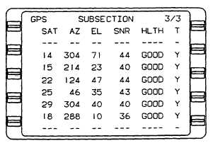
(3) GPS Subsection 3/3 Page. This page
displays the status of the GPS receiver. Refer to
Figure 3A-32. The GPS receiver is an eight-channel
receiver. Information on up to eight satellites can be
displayed under six column titles as follows.
(a) GPS SAT. This field displays GPS
satellite Pseudo Random Noise (PRN) number.
(b) AZ. This field displays GPS satellite
azimuth (AZ) position in degrees.
(c) EL. This field displays GPS satellite
elevation (EL) in degrees above the horizon.
(d) SNR. This field displays GPS
satellite Signal To Noise Ratio (SNR).
(e) HLTH. This field displays GPS
satellite health (HLTH) as BAD or GOOD.
(f) T. This field indicates whether or not
GPS satellite is being tracked (T) by displaying Y (yes)
or N (no).
Figure 3A-32. GPS Subsection 3/3 Page
g. Vertical Navigation Section (VNAV Key).
NOTE
VNAV system is advisory only, it is not
coupled to the autopilot.
In a programmed approach, the altitude
displayed with the MAP (missed approach
point) waypoint is computed through the
MAP waypoint to a point 50 feet above the
runway threshold. MDA (Minimum Descent
Altitude) may be reached prior to the MAP
waypoint. MDA must be observed if the
runway is not in sight.
(1) VNAV 1/3 (Path) Page. Refer to Figure
3A-33.
(a) VNAV Mode (First Line of Display
Below Title). The VNAV mode is the mode required to
fly to the TO waypoint and is displayed in the left field.
The aircraft's current barometric altitude in feet is
displayed in the right field. The VNAV mode line can
display the following.
1 INVALID. INVALID displayed in
the VNAV mode line indicates that the VNAV function
is invalid. In order to be valid, the following conditions
must be met.
a. Air data (barometric altitude
and altitude rate) must be
valid.
b. Must have a valid lateral to
waypoint.
c.
Must have a valid vertical to
waypoint.