TM 1-1510-225-10
3A-59
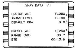
Figure 3A-36. VNAV Data 1/1 Page
(1) CRUISE ALT – This line displays the
manually entered cruise altitude in feet or flight level
(FL). Any altitude that is greater than the transition
level is converted to and displayed as flight level
(rounded off to the nearest hundred feet). An altitude
less than 1000 feet must be entered with a preceding
zero.
NOTE
In a climb, when the aircraft is within 200
feet
of
the
pre-selected
altitude,
the
CRUISE ALT changes to the same value as
the PRESEL ALT.
The field also changes to dashes during a
descent when the aircraft is 200 feet lower
than the CRUISE ALT and the pre-selected
altitude is set to a lower value. Then, when
the aircraft is within 200 feet of the
PRESEL ALT, the CRUISE ALT changes
again to the same value as the PRESEL
ALT.
(2) Transition Level. The transition level
(TRANS LEVEL) field is used to enter the altitude at
which the system will convert altitudes to flight level.
The field defaults to FL 180 if the pilot does not enter a
value.
(3) DEFAULT FPA. This field displays the
manually entered descent default flight path angle
(DEFAULT FPA) in degrees and tenths of a degree
from 0.1° to 6.0°.
NOTE
Enter whole numbers only. The decimal
point is entered by the system.
(4) PRESEL ALT. This field displays pre-
selected altitude (PRESEL ALT) inputs from the
system in feet or flight level.
(5) RANGE (NM). This field displays range
to pre-selected altitude in nautical miles and tenths of
a nautical mile.
(6) ETE. This field displays the estimated
time en route (ETE) to the pre-selected altitude in
hours, minutes, and tenths of a minute.
i. VNAV Waypoint 1/1 Page. Refer to Figure
3A-37.
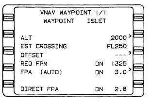
Figure 3A-37. VNAV Waypoint 1/1 Page
(1) WAYPOINT. This field displays the
VNAV waypoint identifier, which may consist of from
one to six alphanumeric characters.
(2) ALT. This field displays the constraint
altitude that pre-fills from the database or can be
manually entered. Any altitude entered that is greater
than the transition level (from the VNAV Data page) is
converted to and displayed as flight level (rounded off
to the nearest hundred feet). An altitude less than
1000 feet must be entered with a preceding zero.
Altitudes below sea level are limited to -1000 feet. The
following may appear in the altitude field.
FL = flight level
A = at or above
B = below
Blank space = at


