TM 1-1510-218-10
3-31
FARM
o . ’
o
. ‘
CRSR
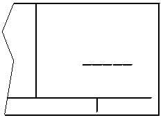
Figure 3-29. User-Defined Airport Waypoint Page
The cursor will be over the dashed latitude field.
The latitude and longitude of the waypoint must be
entered. Turn the right inner knob to display an N or
an S and select the latitude in degrees, minutes, and
hundredths of a minute by using the right inner and
outer knobs. When the complete latitude has been
selected, press the ENT button. The cursor will move
down to the longitude field. Turn the right inner knob
to select E or W. Use the right inner and outer knobs
to select the longitude. Press the ENT button to
approve the waypoint position.
7. Turn the right inner knob one step
clockwise to display the APT 2 page
as illustrated in Figure 3-30. To enter
an airport elevation, press the right
CRSR button and rotate the right
outer knob to position the cursor over
the dashes to the right of ELV. Use
the right inner and outer knobs to
enter the elevation. Press the ENT
button to store the elevation. Press
the right CRSR button to turn off the
cursor.
FARM
ELV FT
APT 2
Figure 3-30. APT 2, User-Defined Airport
Waypoint Page
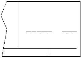
8. Turn the right inner knob one step
clockwise to display the APT 3 page.
Refer to Figure 3-31. To enter a
runway length, press the right CRSR
button and rotate the right outer knob
to position the cursor over the fi ve
dashes directly beneath RWY LEN.
Use the right inner knob to select each
individual digit and the right outer
knob to position the cursor until the
entire runway length is selected.
Press the ENT button to approve the
runway length. The cursor will move
to the surface position. Turn the right
inner knob to select either HRD or
SFT. Press ENT to approve the
runway surface. Press the right
CRSR button to turn off the cursor
function.
FARM
RWY LEN
‘
APT 3
Figure 3-31. APT 3, User Defined Airport
Waypoint Page
Airport remarks may be stored on the APT 5
page.
(2) Creating a User-Defined VOR Waypoint.
A user-defined VOR waypoint must contain an
identifier, magnetic variation, latitude, and longitude.
The magnetic variation may be manually entered or, if
one is not entered, one will automatically be calculated
and stored. A VOR frequency may be stored. The
procedure for creating a user-defined VOR waypoint is
similar to that just described for creating a user-
defined airport waypoint. Begin by selecting the VOR
waypoint pages. The VOR dentifier can be one to
three characters in length. A user-defined VOR
waypoint page contains the user identifier at the top of
the page and three lines of dashes. The top line of
dashes may be filled in with frequency and magnetic
variation. The second line is for latitude and the third