TM 1-1510-218-10
3-24
Table 3-4. Special Use Airspace (Continued)
DISPLAY
EXPLANATION
CL C
Class C
CTA
Control Area (outside the USA)
DNGR
Danger Area
MOA
Military Operations Area
PROH
Prohibited Area
REST
Restricted Area
TMA
Terminal Area (outside the USA)
TRNG
Training Area
WARN
Warning Area
The message prompt for a special use airspace
alert will occur when the aircraft is approximately 10
minutes from penetrating the outer boundary. It will
also occur if the aircraft is within approximately 2 nm of
one of these areas even if the aircraft won't actually
penetrate the area. The pilot selects the amount of
vertical buffer. If one of the areas is penetrated,
another message will state, INSIDE SPC USE
AIRSPACE.
t.
Airport Pages. There are eight airport
pages for every airport in the published database.
The database primary area contains public use
and military airports that have a runway at least 1000
feet in length. The airport pages contain:
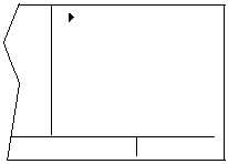
(1) Airport 1 Page. Refer to Figure 3-19.
NOTE
The APT 1 page has a different format
when it is displayed as one of the nine
nearest airports.
(a) Airport Identifier. An arrow precedes
the identifier if the airport is the active waypoint.
(b) Airport Name.
(c) If the airport underlies the outer
boundary of Class B or C airspace, CTA, or TMA, the
letters CL B, CL C, CTA, or TMA will display.
Additionally, if the airport is military, the letters MILTRY
will display.
(d) The latitude and longitude of the
airport reference point.
KORL
EXECUTIVE
CL B
N 28o 32.71’
W 81o 19.99’
APT 1
Figure 3-19. APT 1 Page
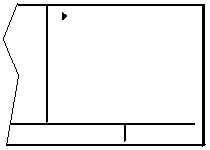
(2) Airport 2 Page. Refer to Figure 3-20.
(a) Airport Identifier. An arrow precedes
the identifier if it is the active waypoint.
(b) The city where the airport is located.
(c) The state, if the airport is located in
the United States, the province if in Canada, or the
country outside of the United States and Canada.
KORL
ORLANDO FL
ELV 110FT
Z-05(-04DT)
ILS (R)
APT 2
Figure 3-20. APT 2 Page
(d) Airport Elevation. The elevation is
rounded to the nearest 10 feet.
(e) Time in relationship to UTC (Zulu).
Z-05, for example, indicates local standard time is five
hours behind UTC time. If the airport is located in an
area which observes daylight savings time, the
information in parentheses shows the daylight savings
time in relation to UTC.
(f) Instrument
Approach
Information.
Refer to Table 3-5 for the various displays and their
explanations.