TM 1-1510-225-10
3D-19
CAUTION
When using the actual track up format, it is
typical for there to be a slight delay from
the time a heading change is made until
the correct map orientation is displayed.
Do not confuse the desired track up
display or the actual track up display with
the heading up display.
(2) When
navigating
using
flight
plan
operation, the active flight plan (FPL 0) waypoints are
displayed using the number associated with the
waypoint as it appears on the FPL 0 page. An arrow
points to the active waypoint and shows the current
flight plan leg. When operating direct to a waypoint
that is not in the active flight plan, the direct to
waypoint is indicated with an asterisk. Refer to Figure
3D-15.
NAV 5
N
40
1
2
4
3
*
Figure 3D-15. Nav 5 Page
(Flight Plan Operation)
(3) To select the desired NAV 5 orientation,
press the appropriate CRSR button. The cursor will be
over the map range scale. Turn the appropriate outer
knob one step counterclockwise to position the cursor
over the map orientation field. Rotate the appropriate
inner knob to display Ná for north up, DTKá for
desired track up, TKá for actual track up, or HDGá
for heading up. If the cursor is moved to the map
range scale using the outer knob or if the cursor is
turned off with the CRSR button, the DTKá , TKá , or
HDGá annunciation is replaced with the actual value.
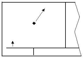
In the North up format and the desired track up format,
the aircraft’s position is depicted by a diamond. In the
actual track up and heading up format, the aircraft’s
position is depicted by an aircraft symbol.
(4) The range scale is displayed in the right
corner of the NAV 5 page. The range scale indicates
the distance from the aircraft’s position to the top of
the screen. Range scale selections from 1 nm to
1000 nm may be made by pressing the appropriate
CRSR button and turning the appropriate inner knob.
(5) When the NAV 5 page is displayed on the
left side of the screen and any selected waypoint page
is displayed on the right side, the location of the
selected waypoint is indicated by a "+" on the NAV 5
page. The display scale must be chosen which allows
the selected waypoint to be displayed.
f. The Super NAV 5 Page. The Super NAV 5
page provides a moving map display of the present
position and route of flight in relation to nearby navaids
and airports. This page is displayed by selecting the
NAV 5 page on both sides of the screen at the same
time. The Super NAV 5 page has a unique format.
There are no page display indicators in the lower left
and right segments of the display. The mode
annunciation is located on the far-left side. The
message prompt will appear in the lower left corner of
the graphics display. Refer to Figure 3D-16.
9.2 NM
LRP
ENR-LEG
200 KT
ETE0:03
DTK113o
TK113o
60
KPHL
MXE
LRP
KMDT
Figure 3D-16. Super NAV 5 Page
(1) The left side of the Super NAV 5 page
shows the following information:
1. Distance to the active waypoint
2. The active waypoint identifier
3. Mode of operation
4. Groundspeed
5. Estimated time en route, cross-track
error, or VNAV status as selected by
the pilot
6. Desired track, bearing to the active
waypoint, or radial from the active
waypoint as selected by the pilot