TM 1-1520-218-10
3C-167
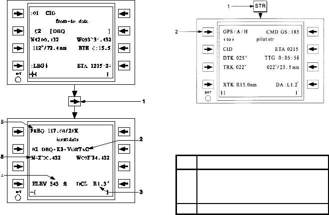
Figure 3C-117. Indent Data Page Access and
Displayed Information
Table 3C-78. Ident Data Page Access and
Displayed Information Procedure
NO.
DESCRIPTION/FUNCTION
1
Scroll horizontally with scroll function
key.
2
ICAO identifier with country code, and
waypoint type (if applicable).
3
Waypoint
Station
declination
or
magnetic variation.
4
Waypoint elevation MSL.
5
Waypoint latitude/longitude.
6
Station
frequency
and/or
TACAN
channel.
r. GPS Integrated Navigation.
(1) Navigational System Overview. The GPS
navigational source used for the pilot’s steering
solution is displayed on the Pilot Lateral Steering
page. Refer to Figure 3C-118 and Table 3C-79.
Figure 3C-118. Pilot Lateral Steering Page
Table 3C-79. Pilot Lateral Steering Page
Procedure
NO.
FUNCTION/DESCRIPTION
1
Pressing the STR function key will access
the last viewed steering page. Vertically
scroll if necessary to access the pilot
lateral steer page.
2
Navigation Source.
(2) Position, Track, and Air Data Displays.
The navigation solution for the GPS navigation source
is displayed on the pilot position page as shown in
Figure 3C-119 and Table 3C-80. The true airspeed
and SAT shown on this page comes from the Air Data
Computer (ADC).
The wind vector is displayed as either a current
wind vector, crosswind component, or head/tail wind
component. For the headwind/ tailwind component, a
- will indicate a tail wind and a ¯ will indicate a
headwind. For the crosswind component, a ® will
indicate a left crosswind with the magnitude to the right
of the arrow, and a ¬ will indicate a right crosswind
with the magnitude to the left of the arrow.
When the groundspeed and true airspeed are
invalid, the numeric display for the wind will be dashed
and the headwind/tailwind and crosswind data will be
removed.