TM 1-1510-218-10
3C-88
2 No waypoints can be inserted
between any two-history waypoints.
3 The last history waypoint (waypoint
00) cannot be deleted.
Sixty waypoints is the maximum number of
waypoints allowed in the active flight plan. The FPLN
FULL message will appear in the scratchpad if an
insertion of a 61st waypoint is attempted.
(d) Renumbering Flight Plan Waypoints.
After inserting or deleting waypoints, there becomes a
requirement to renumber the flight plan to remove
waypoints with alphabetical suffixes. Access the Flight
Plan Edit 2 page and select the RENUMBER line
select key (requires confirmation). This causes all
future flight plan waypoints to be renumbered in
sequence without alphabetic suffixes, starting at the
active waypoint number. The active waypoint and the
history waypoints are not renumbered.
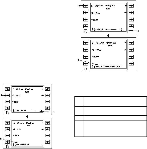
(e) Modifying Waypoint Locations. If a
bearing/distance (e.g., 050/23) is inserted at a
waypoint identifier, that waypoint is offset by the
bearing and distance, and displayed in the scratchpad
with the bearing and distance offset applied. Refer to
Figure 3C-35 and Table 3C-26. If the bearing and
distance is applied at any other type of waypoint (e.g.
latitude/longitude), the FMS-800 computes the offset
latitude and longitude of the position and displays it in
the scratchpad. Refer to Figure 3C-36 and Table
3C-27. In either of the two cases stated above, the
new waypoint can now be inserted into the flight plan.
If the original waypoint needs to be deleted, follow the
procedure in Paragraph 3C-25.e.(3)(c).
Figure 3C-35. Modifying Waypoint Locations
Table 3C-26. Modifying Waypoint Identifier
Location Procedure
NO.
DESCRIPTION/FUNCTION
1
Enter the bearing/distance offset into the
scratchpad.
2
Apply the offset to BRL.
3
Ensure that there is a new waypoint offset
to the desired bearing/distance displayed in
the scratchpad. It may be inserted into the
flight plan as desired.
Figure 3C-36. Modifying Latitude / Longitude
Locations
Table 3C-27. Modifying Latitude / Longitude
Location Procedure
NO
.
DESCRIPTION/FUNCTION
1
Enter the bearing/distance offset in the
scratchpad.
2
Apply the offset to a lat-long.
3
The computed lat-long is displayed in the
scratchpad and available for insertion into
the flight plan (original waypoint may be
deleted manually if desired.)
The bearing is referenced to the Station
declination, for a waypoint that is a VOR, VORTAC,
VOR-DME, or TACAN, and for all other waypoints.


