TM 1-1510-225-10
3B-199
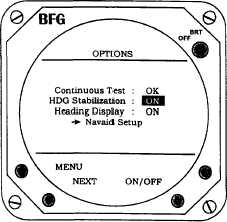
The system will initially power up with the
heading stabilization feature on. Should the aircraft
heading gyro fail, the heading stabilization feature can
be turned off. To turn the heading display on or off,
press the NEXT button to highlight heading display
and press ON / OFF as appropriate. Refer to Figure
3B-157. When on, the heading of the aircraft will
appear as a digital indication at the top of the display
when in either weather mode.
Figure 3B-157. Heading Options
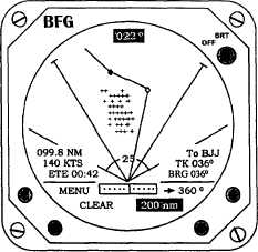
(6) Navaid Option. This option creates a
weather avoidance and navigational view. Refer to
Figure 3B -158. Using data from the KLN-90B, this
option
provides
simultaneous
display
of
both
thunderstorm and flight information on the system
screen. The course line, selected waypoints, and a
course deviation indicator are graphically displayed.
Up to ten waypoints may be display with the selected
nautical mile range. The CDI is calibrated to indicate
the course deviation up to 5 nautical miles on either
side of the course line. Up to six user-selectable data
items can be displayed. The navaid option is selected
from the main menu. Display range, ground speed,
estimated time en route, bearing, crosstrack error, and
estimated time of arrival are automatically displayed.
The data or its position can be changed through the
Navaid Setup function on the Options menu.
Figure 3B-158. Navaid Option
The Navaid Setup grid lists 14 data items and
includes a blank space. Refer to Table 3B -111 for
data items definitions. Up to six items can be
displayed on the weather-mapping screen. To select
an item from the grid, move the highlight by pressing
the NEXT button. Refer to Figure 3B -159. The data
items available for selection are dependent upon the
specific information provided by the KLN-90B receiver.
If an item on the grid is not available from the receiver,
that grid space will include an asterisk.
Table 3B-111. Navigation Data Items
ABBR
USER SELECTIONS
Brg
Bearing to Active Waypoint
ETA
Estimated Time of Arrival
ETE
Estimated Time En Route
GS
Ground Speed
Lat
Latitude
Long
Longitude
MESA
Minimum Enroute Safe Altitude
MSA
Minimum Safe Altitude
Mvar
Magnetic
Variation
at
Present
Position
Rng
Range to Active Waypoint
Time
Stormscope System Stopwatch
Trk
Track
WPT
Waypoint Identifier
XTK
Crosstrack Error