TM 1-1510-225-10
3B-91
Table 3B-40. VNAV Capture and Termination
Alerts
NO.
DESCRIPTION/FUNCTION
1
TOP OF DESCENT label flashes 10
seconds prior to VNAV capture (same for
BOC).
2
Altitude flashes at 1000 feet above/below
waypoint crossing altitude.
3
V attribute flashes 10 seconds prior to
VNAV
capture
and
at
1000
feet
above/below waypoint crossing altitude.
i. Flight
Instrument
and
Autopilot/Flight
Director Guidance.
(1) Flight Instrument Displays. The FMS-800
provides lateral and vertical navigational situation
information to the pilot’s flight displays. The pilot’s
displays are driven using the navigational solutions
from
the
CDU
Pilot
Steering
page,
Paragraph
3B-19.e.(6)(a).
(2) Horizontal Situation Displays (HSI). In
order to display horizontal situational data on the
EHSI, the FMS source must be selected by the pilot.
The EHSI data includes the HSI course arrow (desired
track), TO / FROM pointer, and bearing pointer to the
FMS-800 outputs. These outputs always relate to the
flight plan active waypoint or pattern turn point. Refer
to Figure 3B-55 and Table 3B -41. If the EHSI distance
interface is compatible and aircraft switching is
installed, the distance readout will also show great
circle distance to the active waypoint.
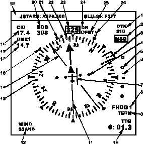
Figure 3B-55. HSI Display
Table 3B-41. HSI Display
NO.
DESCRIPTION/FUNCTION
1
Course Readout/Label
2
FMS Message Alert
3
FMS Heading Bug
4
Course Deviation Scale
5
Vertical Deviation Scale
6
Vertical Deviation Pointer
7
Lateral Deviation Bar
8
Course Source
9
FMS Flight Modes
10
Selectable Navigation Data
11
Course Pointer
12
Wind Direction (Deg)/Velocity (Knots)
13
Compass Rose
14
Bearing Pointer
15
Compass Benchmark
16
Distance of Bearing Source
17
Bearing Source
18
Distance to Course Source
19
Free Format Line (ARC-210 Freq)
20
Digital HDG Bug Readout
21
Heading Bug
22
Track Indicator
23
Digital Heading Readout
24
DR or RAM Alert
25
FMS OFST
26
Wind Pointer
The course/desired track readout and pointer on
the EHSI show the great circle desired track at current
aircraft position along the active leg. This may differ
from the CRS display on the CDU Flight Plan page
when the distance to the waypoint is large, especially
at high latitudes. The CRS display on the Flight Plan
page always references the inbound track measured
at the waypoint. Refer to Figure 3B-56.
When the inbound course to the active waypoint
is manually entered on the Flight Plan page, the
course display and course pointer on the HSI show the
desired course at the waypoint.