TM 1-1510-218-10
3C-114
Figure 3C-59. VNAV Profile
(6) VNAV Guidance and Alerting. After a
waypoint with an altitude becomes active, the FMS-
800 provides vertical steering to fly the entered or
default VNAV climb or descent path. On the Pilot
VNAV Steering page, the specified VNAV path
parameters are displayed on data line 2. The
continuously updated altitude is on data line 1 and the
vertical rate and angle for a direct vertical path to the
waypoint are presented on data line 3.
Prior to VNAV capture, the distance to the
BOC/TOD is displayed. This display is dashed after
the VNAV path is captured.
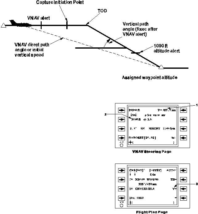
Figure 3C-60 and Table 3C-46 show a typical
VNAV profile along with the alerts associated with the
VNAV capture and termination. Ten seconds prior to
the VNAV path capture, the CDU page alerts flashes.
At an altitude 1000 feet below/above the waypoint
crossing altitude, a second alert is issued.
When the active waypoint for the VNAV
guidance passes into history or is deleted, the VNAV
steering parameters become invalid or are reset to
their default values for the next vertical waypoint in the
flight plan.
Figure 3C-60. VNAV Capture and Termination
Alerts


