TM 1-1510-218-10
3C-113
Table 3C-44. VNAV Direct-To Procedure
NO.
DESCRIPTION/FUNCTION
1
Press the Direct function key - DIR.
2
Select VNAV Direct-To the active
waypoint, if it has an altitude/flight level
assigned (indicated by the V attribute).
If the waypoint on line 3 does not have
an altitude/flight level assigned, the
VNAV label is blanked.
3
Indicates V attribute.
4
VNAV
CLIMB/DESCNT
path
synchronizes to the Direct-To path.
If an angle is entered, the vertical rate will be
dynamically updated based on the angle prior to and
during capture and the subsequent vertical path. An
* will appear next to the angle value to indicate that it
is fixed. If a vertical rate is initially entered, the
angle is updated based on the entered rate prior to
the capture points plus an * appears next to the rate.
At capture of the vertical path, the angle becomes
fixed and the entered rate is now updated during the
climb/descent. The * is now displayed next to the
angle to indicate the fixed value.
(4) Direct Climb or Descent Path Display.
The DIRECT CLIMB/DESCNT vertical rate or angle
on the Flight Plan Waypoint page is computed
based on the FMS-800 present position and altitude
for any waypoint with an altitude assigned, not just
for the active waypoint. Refer to Figure 3C-58 and
Table 3C-45. This advisory enables the pilot to plan
his climb or descent. He is apprised of the actual
vertical maneuver required. For example, ATC
delays his climb/descent clearance beyond the
planned Bottom Of Climb (BOC) or Top Of Descent
(TOD), or clears the aircraft Direct-To another
waypoint using the specified waypoint altitude. This
is also the value that will be inserted if the pilot were
to select a VNAV Direct-To.
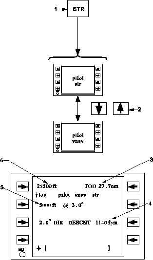
Figure 3C-58. VNAV Steering Pages
Table 3C-45. VNAV Steering Page Procedure
NO.
DESCRIPTION/FUNCTION
1
Pressing the Steering function key – STR will
access the last viewed Steering page.
2
Scrolls vertically between the Steering pages.
3
Indicates the distance to BOC/TOD.
4
Indicates direct VNAV guidance.
5
Specified altitude/flight level and path angle to
the active waypoint.
6
Current aircraft altitude.
(5) VNAV Direct-To. To perform a VNAV
Direct-To climb or descent, follow the procedure
specified in Figure 3C-59.