TM 1-1510-225-10
3B-66
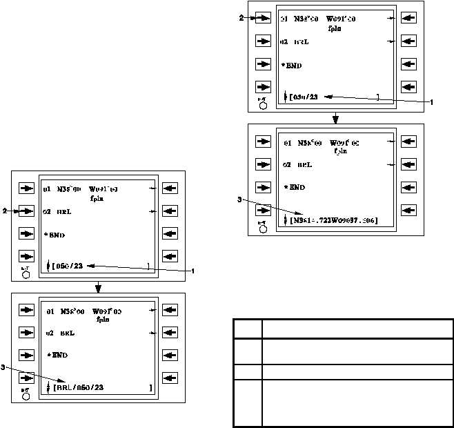
(e) Modifying Waypoint Locations. If a
bearing/distance
(e.g.,
050/23) is inserted at a
waypoint identifier, that waypoint is offset by the
bearing and distance, and displayed in the scratchpad
with the bearing and distance offset applied. Refer to
Figure 3B -29 and Table 3B-20. If the bearing and
distance is applied at any other type of waypoint (e.g.
latitude/longitude), the FMS-800 computes the offset
latitude and longitude of the position and displays it in
the scratchpad. Refer to Figure 3B -30 and Table
3B-21. In either of the two case stated above, the new
waypoint can now be inserted into the fight plan. If the
original waypoint needs to be deleted, follow the
procedure in Paragraph 3B -19e(3)c.
Figure 3B-29. Modifying Waypoint Identifier
Locations
Table 3B-20. Modifying Waypoint Identifier
Locations
NO.
DESCRIPTION/FUNCTION
1
Enter the bearing/distance offset into the
scratchpad.
2
Apply the offset to BRL.
3
Ensure there is a new waypoint offset to the
desired bearing/distance displayed in the
scratchpad. It may b e inserted into the
flight plan as desired.
Figure 3B-30. Modifying Latitude / Longitude
Locations
Table 3B-21. Modifying Latitude / Longitude
Locations
NO.
DESCRIPTION/FUNCTION
1
Enter the bearing/distance offset in the
scratchpad.
2
Apply the offset to a lat-long.
3
The computed lat-long is displayed in the
scratchpad and available for insertion into
the flight plan (original waypoint may be
deleted manually if desired).
The
bearing
is
referenced
to
the
Station
declination, for a waypoint that is a VOR, VORTAC,
VOR-DME, or TACAN, and for all other waypoints.
(f) Waypoints with Duplicate Identifiers.
If a waypoint identifier is entered which is duplicated in
another area of the world, the Select Waypoint page is
automatically accessed and displays the data for up to
20 waypoints having that identifier. Refer to Figure
3B-31 and Table 3B-22. If more than two do exist, the
pages can be scrolled for viewing. Up to 19 duplicate
identifiers will be searched from the primary ICAO
database on the cartridge. One duplicate identifier will
be searched from the User Waypoint list. The
identifiers are ordered from closest to present position
to furthest from present position when the navigation
solution is valid. Select the desired waypoint by