TM 1-1510-218-10
3-4
Figure 3-2. KLN 90B External Switches and Annunciators T2 (Sheet 3 of 3)
d. Database. The databases for the KLN 90B
have a primary and a secondary coverage area. All
databases
contain
complete
information
for
all
worldwide VOR's, NDB's, and Minimum Safe Altitudes
(MSA's). For its primary area, the database contains
public use and military airports that have any runway
at least 1000 feet in length. For its secondary area,
the database also contains airports having a hard
surface runway at least 3000 feet in length. Airport
communication frequencies and runway information
are provided only for airports in the primary area.
Intersections, air route traffic control center data, flight
service station frequencies, and special use airspace
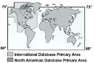
are also provided only for the primary area. Refer to
Figure 3-3.
Figure 3-3. Database Area
The following is a list of the KLN 90B database
contents.
NOTE
Items
indicated
with
an
asterisk
are
included in the primary database coverage
area, but not in the secondary coverage
area. The exception is that airports in the
primary coverage area include those public
and military bases having a runway at least
1000 feet in length. Airports in the
secondary coverage area are those having
a hard surface runway at least 3000 feet in
length.
(1) Airports*
(a) Identifier.
(b) Name.
(c) City, State, or Country.
(d) Type (public or military).
(e) Latitude and Longitude.
(f) Elevation.
(g) Approach indicator for precision, non-
precision, or no instrument approach at the airport.
(h) Radar
approach/departure
environment indicator.
(i) Whether airport underlies CL B,
TRSA, CL C, CTA, or TMA.
(j) Time relative to UTC (Zulu).
(k) Communication frequencies.
1 ATIS.
2 Clearance delivery.
3 Tower.


